


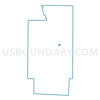
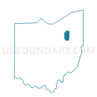
PRECINCT CUY FALLS 6-A, Summit County, Ohio
About
Outline

Summary
| Unique Area Identifier | 652033 |
| Name | PRECINCT CUY FALLS 6-A |
| County | Summit County |
| State | Ohio |
| Area (square miles) | 0.16 |
| Land Area (square miles) | 0.16 |
| Water Area (square miles) | 0.00 |
| % of Land Area | 100.00 |
| % of Water Area | 0.00 |
| Latitude of the Internal Point | 41.15575090 |
| Longtitude of the Internal Point | -81.48063120 |
Maps

Graphs
Select a template below for downloading or customizing gragh for PRECINCT CUY FALLS 6-A, Summit County, Ohio


Neighbors
Neighoring Voting District (by Name) Neighboring Voting District on the Map
- PRECINCT CUY FALLS 5-B, Summit County, OH
- PRECINCT CUY FALLS 6-B, Summit County, OH
- PRECINCT CUY FALLS 6-C, Summit County, OH
- PRECINCT CUY FALLS 6-E, Summit County, OH
- PRECINCT CUY FALLS 6-F, Summit County, OH